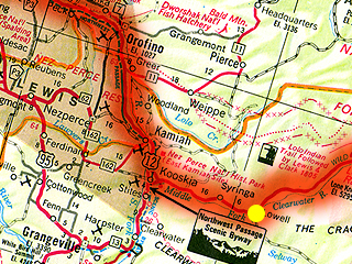
Lewiston ID to Lowell ID

Clearwater River
| Distance | (miles) |
|---|---|
| Day | 97 |
| Total | 537 |
| Speed | (mph) |
| Average | 11.6 |
| Maximum | 28.5 |
| Expenses | ($ US) |
| Lodging | 42.80 |
Ate at Waffleville (that's not the exact name), but for some strange reason I ordered an omelette. Today was very simple to describe. Stayed on US Highway 12 the entire day. The highway parallels first the Clearwater River then the Middle Fork Clearwater River. The green is coming back and there are more and more trees. I have just left the Nez Perce Indian Reservation and am now in the Clearwater National Forest. This is a very scenic area. The river is moderately swift. I have seen quite a wide variety of raptors (hawks, falcons and eagles, but I can't tell them apart). Plenty of babbling brooks to feed the river. Before entering the National Forest there were very few houses or towns, but when there were they always had at least one fireworks stand and a yard sale or two. The wheat fields have ended. I am approaching the middle of nowhere. There are few bridges across the river, but in some locations there are private cable cars to the other side.

Traffic has been excellent. This being a holiday has meant few cars and almost no trucks. Reports of this road warned me of heavy truck traffic and I am glad I have not seen it. There is almost no shoulder and sight distances are occasionally too short for comfort. I am very careful about blind turns and look behind me before entering them. When I see traffic behind me I slow down to let them pass or speed up to get out of their way.
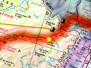
I have been riding uphill for the majority of the day. There was one short downhill near the beginning, but otherwise the grade has been consistant. It's getting to the point where a slightly less steep part of the highway looks like a downhill. The altitude here is something like 1200 feet. That was a major disappointment. I am still over 3500 feet from Lolo Pass. The next services are 65 miles away in a place called Powell. The nearest motel is booked up and it is over 100 miles to Missoula. It cost $3.05 to call Powell from Lowell where I am right now. It's the same area code so I could not use my calling cards. There is a 5 to 10-mile portion that looks too steep to ride, but that remains to be seen. In any case it looks like it will be a long, difficult day tomorrow. I am going to try to get out of here early and ride slow and steady the 65 miles to Powell where I should probably break for lunch. (I have not eaten a lunch yet on this trip.) From Powell it's an additional 13 miles to Lolo Pass with at most 6 miles of walking. Of course it's all downhill to Missoula, but I have no idea what kind of strength I will have nor how far I will be able to coast. The maps and guides I have are not very explicit about the services after Lolo Pass. There's also another hot springs, but I can't figure out if there's any kind of lodging nearby. I will also lose an hour crossing into the Mountain Time Zone.
I cannot post this message today. My room is not equipped with a phone. It also has a TV with only one channel (NBC West) featuring the local news from Los Angeles (no joke). The last weather report I heard said a chance of showers in the late afternoon for tomorrow. That's the same prediction they made for today. I can live with that.
 |
 |
 |
 |
 |
 |
 |
 |
 |